'Medicane' left Libya trapped between floods and the sea
Sep 13, 2023
Tripoli [Libya], September 13: It's the heaviest rainfall Libya has seen in the past 40 years. Storm Daniel had already caused severe floods in Greece, Bulgaria and Turkey. Then, above the warm waters of the Mediterranean Sea, it swelled to a so-called "medicane" - a portmanteau of "Mediterranean" and "hurricane."
It was the result of a weather pattern known as an "Omega block." Now dissipated, the omega block over central Europe had led to a series of unusually hot late-summer days. Low-pressure systems from the Atlantic, approaching from the northwest, subsequently caused this high-pressure effect to shift southeast.
Storm Daniel brought torrential downpours to Greece, Bulgaria, and Turkey before moving toward the northern African coast, which it hit with storm surges and heavy floods.
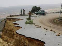
The devastation was particularly catastrophic in Libya, which has been plagued by civil crisis and political instability since 2011. Coastal towns to the north of the country have been flooded, with dams breaking and entire neighborhoods being swept away. Thousands are feared dead.
A medicane is a cyclone over the Mediterranean Sea. The term was coined in the 1980s when satellites picked up images of cloud patterns reminiscent of a hurricane over the Mediterranean. Like a hurricane, they were shaped in a spiral, with a cloudless center, known as the "eye" of the hurricane. Spinning around the eye at high wind speeds were sheets of clouds and rain. Hence, the combination of the terms "Mediterranean" and "hurricane."
With a diameter of 300 kilometers (186 miles) at most, medicanes are significantly smaller than hurricanes, which can reach five times that size. They usually dissipate after a few hours and rarely last two days. Hurricanes, on the other hand, frequently build momentum over the span of an entire week.
Medicanes such as storm Daniel are most frequent in the autumn but can be observed throughout the winter. They develop when cold air from temperate latitudes pushes towards the equator, forming what's known as a cut-off low - or cold drop - in the upper air flow. The low-pressure system that became storm Daniel was one such isolated cold drop.
The summer was far hotter than usual, which left the Mediterranean Sea warmer than usual. Once water temperatures rise above 24 degrees Celsius (75.2 degrees Fahrenheit), water vapor condenses and creates a cloud vortex. In most cases, these vortexes do not exceed wind speeds comparable to those of a tropical storm, which are approximately between 63 and 118 kilometers per hour (39 and 73 miles per hour). However, they carry immense amounts of water, which can lead to severe floods.
The medicane hit the coastal cities Derna and Jabal al-Akhdar particularly hard, as well as the towns of Sus and Marj. Other damaged towns include Bayda, as well as the key port city of Benghazi.
The fact that cities along the coast were so severely affected is in part due to Libya's topography. The thin strip of coast is encircled by a long and steep mountain plateau that spans some 300 kilometres. On average, the mountainous range is about 400 meters to 600 metres (1,312 feet to 1,969 feet) high, with the highest point reaching 880 meters. Its northern face has a relatively steep drop towards the Mediterranean and is rocky and jagged, marked by numerous water courses and covered with loose red soil.
It was along this plateau that the extreme rain clouds dumped the immense amounts of water they carried. Unable to absorb the deluge, rivers and lakes swelled over their banks and spilled down the slopes to the valley below in flash floods. In this way, coastal towns were practically surrounded on all sides by cascades of water. Eventually, dams were no longer able to withstand the pressure, causing huge swathes of land to flood in a very short time.
Source: Times Of Oman